|
|
|

|
Southwest USA 2005
July 10th - July 27th 2005
|
|
|
Day 1-4: Sunday, July 10th - Wednesday, July 13th 2005
|
N/A
|
Braunschweig (~04:00 Central European Time)
--->
Frankfurt
--->
Dallas Fort-Worth, TX
--->
Tucson, AZ (~16:30 Pacific Time)
|
|
|
 Weather: Tucson is slightly hotter than usual at around 42C (108F) these days ("but it's a dry heat") and Monsoon season is late, meaning bright sunshine practiaclly all the time.
These first four days are the business part of trip, an aerospace propulsion conference.
Highlights:
- Great Tex/Mex food (accompanied by Mariachi bands for the operning reception on Sunday).
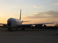
- A visit to the excellent Pima Air & Space Museum on Tuesday evening, which showcases aircarft past and present, from beautiful to bizarre, parked in the desert of Tucson (remember: "it's a dry heat").
- Speech by living legend Burt Rutan at the conferences Awards Luncheon on Wednesday focused on his SpaceShipOne successes and underlines his unique stature in aerospace as being one of the last few remaining individuals with an amazingly comprehensive knowledge of the complete aircraft.
Picked up my car, a funky orange Pontiac Sunfire on Wednesday evening at the airport, which officially kicked off the vacation part of the trip.
|
|
Day 5: Thursday, July 14th 2005
|
199 miles/320km traveled
|
Tucson, AZ (09:30)
--->
AMARC at Davis-Monthan Air Force Base, Tucson, AZ (10:45-11:45 Pacific Time)
--->
Saguaro National Park (Rincon Mountain District), Tucson, AZ (13:00-15:30 Pacific Time)
--->
Pinal Air Park, Marana, AZ (17:15)
--->
Chandler Municipal Airport, Chandler, AZ (18:30)
--->
Phoenix, AZ (20:00)
|
|
|
 Weather: Sunny and hot at around 42C (108F), but yes, "it's a dry heat"
Cell phone alarm goes off at 06:30 and after the motel breakfast check out is at 09:30
First sight to see is the AMARC (Aerospace Maintenance and Regeneration Center) at Davis-Monthan Air Force Base in Tucson, AZ.
Both an aircraft boneyard are here as well as storage of past and present military aircraft such as F-14 Tomcat, F-18 Hornet, F-4 Phantom, A-10 Thunderbolt, A-7 Corsair, Lockheed C-130 Hercules, Boeing KC-135 Stratotanker, A-6, and P-3 Orion. Tours are available through the Pima Air & Space museum, but this time I only try to see all I can thorugh the chain-link fence. And yes, the planes are here because "it's a dry heat".
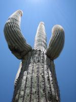
A visit to the eastern Saguaro National Park is next, which features the gigantic Saguaro cactus, which reaches a height of up to 50ft (15m) during its 175 year life span, and other Sonoran Desert flora and fauna. I was too slow to get a photo of a coyote crossing the street (with its' tongue dragging on the floor) as well as a blacktailed jackrabbit which quickly scurried off into the brush as my camera lens extended with a hum. I went on the short 1/4 mile "Desert Ecology Trail" and the 1 mile "Freeman Homestead Trail" hikes, which give an impression of the unuque Sonoran Desert flora. The admission fee of $5 is included in the $50 National Parks Pass, which i purchase here, and is valid for a full year.
Before heading north the purchase of the obligatory $1.99 styrofoam cooler and ice for the drinks was taken care of. This essential part of any Southwest vacation I remembered from the family trip to the region almost 15 years ago (yikes, that's a big number...).
No luck in getting close to seeing anything at Pinal Air Park near Marana, AZ, where white-tails and other commercial aircraft are supposedly stored... :-( But yes, the "dry heat" is the reason they are here, and you do see a number of vertical stabilizers looking from the exit ramp of I17.
Similiarly, no luck in seeing old prop-liners stored at Chandler Municipal Airport neat Phoenix, AZ. It turns out I picked the wrong airport in Chandler, with the Chandler Memorial Airport a few miles west being the correct address... :-( Next trip I guess, which is also when I'll plan to stop by other Phoenix area airfields (Goodyear, Falcon Field) as well as Victorville and Mojave in California, where aerospace nerds are sure to find something to look at. :-)
|
|
Day 6: Friday, July 15th 2005
|
256 miles/412km traveled
|
Phoenix (08:55)
--->
Phoenix Sky Harbor International Airport (09:45)
--->
Montezuma Castle National Monument, AZ (13:15-13:45)
--->
Sedona, AZ (15:00)
--->
Flagstaff, AZ (16:30)
--->
Tusayan, AZ/Grand Canyon National Park, AZ (18:15)
--->
Grand Canyon National Park, Yavapai Point (19:15-20:15)
--->
Tusayan, AZ/Grand Canyon National Park, AZ (20:45)
|
|
|
 Weather: Sunny and hot at around 42C (108F), 35C (95F) towards the Canyon with early afternoon t-storms around Sedona
Cell phone alarm goes off at 07:30 and after a small motel breakfast check out is at 08:55
Picked up my sister at Phoenix Airport at 10:00.
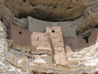
Visit of the Montezuma Castle National Monument, built 100ft above the Verde Valley in a cliff recess early in the 12th century by southern Sinagua farmers. At discovery it was thought to be of Aztec origin, thus its name. Admission is $3 per person, included in the National Parks Pass.
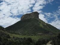
Drive via highways US179, US89, I17, US180 through the Oak Creek Canyon, Sedona, Flagstaff and the Coconino and Kaibab National Forests, which also features some of the first of the spectatcular large red rocks on this trip.
Afternoon t-storm (which we drove through a bit just past Sedona) seem to have hit powerlines, which result in power-outage for many areas north of Williams, AZ. While the weather improves quickly, our motel is still affected as we check in, but power comes back soon.
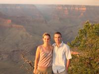
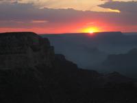 First entry into the Grand Canyon National Park at 19:00 to view a very nice sunset from Yavapai Point (at around 19:45). The park entrance fee is $20 for a week, but is included in the National Parks Pass.
Amongst souvenirs (Saguaro cactus seeds for me) and other things my sis and myself bought a bottle of white wine tonight. Due to the lack of a corkscrew and lazyness and forgetfulness in obtaining one, this bottle will travel with me for much of the remainder of the trip.
|
|
Day 7: Saturday, July 16th 2005
|
36 miles/58km traveled
|
Tusayan, AZ (08:00)
--->
Grand Canyon Village (08:30)
Hermits Rest (09:20), Santa Maria Spring (11:05-12:00), Hermits Rest (13:45),
Mohave Point (14:00), Grand Canyon Village (15:00)
--->
Pool break @ Motel in Tusayan, AZ (16:00-18:00)
--->
Mather Point (18:15), Yaki Point (19:00-20:00)
--->
Tusayan, AZ/Grand Canyon National Park, AZ (21:00)
|
|
|
 Weather: Sunny and hot at around 35C (95F)
Cell phone alarm goes off at 06:30
After driving into Grand Canyon National Park and parking the car at Grand Canyon Village we take the bus to the western most stop at Hermits Rest.
We hike down Hermits Trail to Santa Maria Spring, covering a total of 5 miles (8km) and en elavation of 1680ft (512m). The hike is a lot of fun, but the way up in particular is quite strenuous due to the noon heat and some (short) wrong turns. Compare our before and after rest stops... :-) I guess this explains why most people were actually already on their way up again as we walked down; so starting really early is the key!
After the hike we hang out at the motel pool for a while.
We head back to the Grand Canyon National Park at 18:00 to view an even nicer sunset from Yaki Point (at around 19:45).
|
|
Day 8: Sunday, July 17th 2005
|
488 miles/785km traveled
|
Tusayan, AZ (08:00)
--->
Grand Canyon National Park Desert View Drive, Desert View Watchtower (08:00-09:30 Pacific Time)
--->
Colorado Gorge Viewpoint, AZ (09:50-10:10 Pacific Time)
--->
Navajo Bridge/Marble Canyon, AZ (11:30-11:45 Pacific Time)
--->
Lower Antelope Canyon, AZ (12:15-14:00 Pacific Time)
--->
Zion National Park, UT (17:30-18:00 Mountain Time)
--->
Las Vegas, NV (19:30 Pacific Time)
--->
The Strip to Las Vegas Airport, NV (21:40 Pacific Time)
--->
The Strip @ Las Vegas, NV (21:50-00:00 Pacific Time)
--->
Super 8 Motel near Nellis AFB @ Las Vegas, NV (00:15 Pacific Time)
|
|
|
 Weather: Sunny and hot at around 35C (95F), even hotter in Vegas @ 46C (115F).
Localized columns and clouds of smoke from wildfires in the area make for interesting interactions with the sun.
Cell phone alarm goes off at 06:00 Pacific Time
Another drive into Grand Canyon National Park along Desert View Drive, stopping at several viewpoints including the Desert Watchtower at the east entrance.
Drive up north towards Page, AZ with a detour to see the Navajo Bridge and the Marble Canyon.
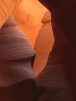
Young Navajo Kyle shows us the spectacular Lower Antelope Canyon, a beautifully smooth orange sandstone slot canyon. Admission to this Navajo-operated wonder is $18.50 per person.
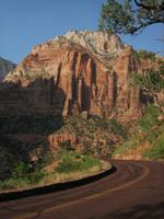
After crossing into Utah, a quick stop at the BLMs Paria Office to inquire about Wave permits 89 and 9 take us into Utah, through Kanab and the Zion National Park, where we are treated to seeing the rare Big Horn Sheep. The admission fee to Zion is also $20, but is included in the National Parks Pass.
Entering Utah from Arizona also means crossing into the Mountain Time zone, as Arizona does not use Daylight Savings Time in the summer months. So suddenly it's an hour later; but as we head into Nevada, which is back on Pacific Time, that hour is given back to us.
 I15 takes us into Nevada towards Las Vegas, where we drive down The Strip before my sister catches a red-eye back to NYC from the airport.
My Super 8 Motel in Las Vegas is close to Nellis AFB and on arrival three F-16s of the USAF Thunderbirds fly in for landing at the base.
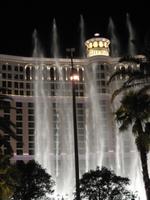
A brief tour of the glitzy hotels and their shows along The Strip is the minimum I had to do in Las Vegas. No money lost, none gained. :-)
|
|
Day 9: Monday, July 18th 2005
|
240 miles/386km traveled
|
Las Vegas, NV (08:10 Pacific Time)
--->
Valley of Fire State Park, NV (10:25-11:30 Pacific Time)
--->
St George, UT (13:30 Mountain Time)
--->
Zion National Park, UT (15:30-20:00 Mountain Time)
Bus Tour (15:45-19:00 Mountain Time)
Emerald Pool Hike (16:15-17:30 Mountain Time)
--->
Kanab, UT (21:00 Mountain Time)
|
|
|
 Weather: Sunny and hot at around 46C (115F) in Vegas, and slightly cooler at 41C (106F) in UT
Cell phone alarm goes off at 06:30 Pacific Time.
To satisfy a sudden craving for chocolate chip pancakes I have my breakfast at an IHOP in Las Vegas before heading north again on I17.
Plenty of deep red rocks and petroglyphs can be found at Valley of Fire State Park just north of Vegas. As a state owned park admission of $6.00 is not covered by the National Parks Pass.
And going from Nevada back to Utah again "costs" me an hour.
I spend more time in impressive Zion National Park today, taking the bus tour along the canyon and along the Virgin River and also hiking about 3 miles along the Emeralds Pool and Kayenta trails. At the northern most stop of the bus I spend a few minutes to dangle my feet in the refreshingly cool water of the Virgin River before heading back to the visitor center.
The setting sun during my drive through and out of Zion to the east casts the red rocks in even more splendid colors.
I make the Super 8 Motel in Kanab, UT my home base for the next two days.
|
|
Day 10: Tuesday, July 19th 2005
|
292 miles/470km traveled
|
Kanab, UT (08:15)
--->
BLM Paria Station, UT (08:55-10:00)
--->
Old Paria Movie Set, UT (10:15-11:15)
--->
Kanab, UT (11:40)
--->
Bryce Canyon National Park, UT (15:00-19:00)
--->
Kanab, UT (20:32)
|
|
|
 Weather: Sunny and hot at around 40C (104F) in southern UT, and slightly cooler at 30C (86F) at Bryce Canyon, UT
Cell phone alarm goes off at 06:00.
Early morning run (to beat the heat) around the red rocks in Kanab (06:40-07:30).
The first stop of the day after the motel breakfast is the Bureau of Land Managements (BLM) Paria Station to obtain a permit for The Wave, which go on sale at 09:00 (Utah Mountain Time!) daily.
Thankfully, the hot summer heat makes me one of only 8 people on line for the 10 $5.00 permits available for the next day.
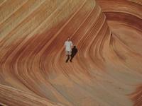
The Wave is a breathtakingly beautiful but very fragile sandstone wonder, which is why access to the area is limited to 20 people per day (10 more permits can be obtained via the web 3 months in advance, in an updated online permit system since January 2006).
This also explains the "secrecy" about the exact location of The Wave, which I feel is justified to protect this unique area.
Rangers do frequently patrol the area, and being there without a permit could cost you up to $300.
So please, respect both the rules and this natural marvel!
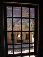
A little detour to the Old Paria Movie Set via a dirt road shows a cute little western town used for several 1960s and 70s films such as Clint Eastwoods "The Outlaw Josey Wells".
On the way to Kanab a Rockwell International B-1B bomber does a low-altitude, high-speed fly past between US89 and the red rocks. Hey, for an aerospace engineer that's pretty cool. :-)
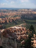 After lunch and postcards in Kanab I head for Bryce Canyon National Park. Again, the $20.00 admission fee is covered by the National Parks Pass. At the park I marvel at the truly spectacular rock formations as I walk along the Bryce Amphitheater from Sunrise Point to Inspiration Point. After driving up to the parks highest peak at Rainbow Point I drive back out of the park by way of all of the viewpoints along the road.
Just outside of the park I stop at a "Rock Shop" and buy a few small samples of the beautiful red rocks as souvenirs.
|
|
Day 11: Wednesday, July 20th 2005
|
272 miles/438km traveled
|
Kanab, UT (05:30 Mountain Time)
--->
Wire Pass Trailhead, Paria Canyon, Vermillion Cliffs Wilderness (06:50 Mountain Time)
The Wave, Paria Canyon, Vermillion Cliffs Wilderness (07:50-09:50 Mountain Time)
Wire Pass Trailhead, Paria Canyon, Vermillion Cliffs Wilderness (11:15 Mountain Time)
--->
Glen Canyon Dam and Page, AZ (12:00-15:00 Pacific Time)
--->
Monument Valley, AZ (16:45-19:00 Mountain Time)
--->
Mexican Hat Lodge in Mexican Hat, UT (19:50 Mountain Time)
|
|
|
 Weather: Sunny and hot at around 42C (108F) in southern UT
Cell phone alarm goes off at 04:50 to be able to beat the heat for the hike to The Wave in the Coyote Buttes North Unit.
Being too early for the motel breakfast I grab some cereal bars at a gas station around 05:30 and reach the Wire Pass Trailhead at 06:50 - after first just missing the dirt road heading off south from the US89.
I am one of the last of the small early morning group heading out to The Wave.
I catch up to the rest on the last part of the moderately strenuous 3 mile hike out to The Wave.
The BLM documentation on how to find this truly breathtaking natural wonder in the absence of marked trails is excellent with maps, photos, descriptions and GPS coordinates.
And once there, The Wave is totally worth spending a few hours to explore...
Heading back a bit later than most of the rest of the early group to check out the Second Wave, we all arrive back at the trailhead before the mid-day heat.
A brief stop at Glen Canyon and a nearby overlook is followed by lunch at a sandwich place in Page, AZ.
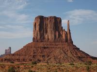 In the afternoon I reach Monument Valley, UT.
As a Navajo-operated park the admission of $5.00 per person is not covered by the National Parks Pass.
A slightly bumpy dirt road does a 17-mile loop to a number of viewpoints.
Navajo jewelery, some of which is really quite nice, is sold at all of them.
Being a little tired due to the early start of the day I'm having a little less fun at this park than I actually should be; but the buttes are a sight worth seeing.
In the afternoon I reach Monument Valley, UT.
As a Navajo-operated park the admission of $5.00 per person is not covered by the National Parks Pass.
A slightly bumpy dirt road does a 17-mile loop to a number of viewpoints.
Navajo jewelery, some of which is really quite nice, is sold at all of them.
Being a little tired due to the early start of the day I'm having a little less fun at this park than I actually should be; but the buttes are a sight worth seeing.
Camp for the night is at the Mexican Hat Lodge in Mexican Hat, UT. The town is named for a rock formation just north of the city, which resembles a sombrero.
|
|
Day 12: Thursday, July 21st 2005
|
276 miles/444km traveled
|
Mexican Hat, UT (08:20 Mountain Time)
--->
Goosenecks State Reserve, UT (08:30-09:00)
--->
Valley of the Gods, UT (09:10-10:15)
--->
Muley Point, UT (11:00-11:20)
--->
Natural Bridges National Monument, UT (12:15-13:50)
--->
Hite Overlook, UT (15:00?)
--->
Hanksville, UT (16:00)
--->
Goblins State Park, UT (16:30-18:00)
--->
Little Wild Horse Canyon, UT (18:20-19:45)
--->
Green River, UT (21:00)
|
|
|
 Weather: Sunny and hot at around 42C (108F)
Cell phone alarm goes off at 06:50.
The first stop is at Goosenecks, which allows a view of a textbook example of the meandering San Juan River.
While similar to Monument Valley in more than just the 17 mile length of the loop drive, Utahs richness in terms of natural wonders means the beautiful rock formations at the Valley of the Gods only make it to BLM administered area. Admission is free and the drive through the park on a good quality dirt road is well worth a detour.
Another lesser known but very spectacular view of the San Juan River can be had from Muley Point, which is reached via a wonderfully twisty part of Highway 261 (sometimes just gravel) and a side trip along a dirt road.
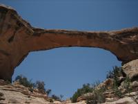
Three bridges and a small ruin can be visited at Natural Bridges National Monument. Admission is $6.00 per vehicle, free with the National Parks Pass. I visit all the viewpoints and do the hike to the base of Owachomo bridge. The parks power is drawn entirely from a series of solar panels, which made up the largest solar power plant when it was built in the 1980s.
The feared long and boring drive north on US95 West turns out to be quite the opposite! The moniker "Scenic Byway" is more than justified with little traffic and plenty of great views making this one of the nicest stretches of driving I have done.
Just passed this bridge in Hite (see also the Google Map) theres a small airfield, from which a Cessna was lumbering into the air as I passed by. Flying here in the canyons does sound like a lot of fun.
After a late lunch/early dinner in Hanksville I make it to Goblin Valley State Park at around 16:00. As a State Park the National Parks Pass does not free me from paying the $5.00 per vehicle admission, but the vast array of red hoodoos in several valleys on the park is well worth the visit.
 Just a few miles away is the Little Wild Horse Canyon. As I only make it to the trailhead at around 18:20, I merely venture into this very nice slot canyon for about 3/4 of its length. The hike is truly fun, with some small climbs necessary here and there and the walls reaching a little more than shoulder width in places.
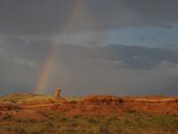
After the LWHC-hike some isolated t-storms in the area make for a very interesting evening sky and sunset. I reach Green River, UT with the distinct feeling of having experienced pretty much a perfect day - which even a dust storm while filling up the car, which was down to the last few drops, couldn't spoil.
|
|
Day 13: Friday, July 22nd 2005
|
217 miles/349km traveled
|
Green River, UT (08:10)
--->
Arches National Park, UT (09:00-14:00)
Delicate Arch Hike, UT (09:30-10:50)
Windows, Turret and Double Arch Hike, UT (12:15-13:15)
--->
Dead Horse Point State Park, UT (14:45-15:15)
--->
Canyonlands National Park, Island in the Sky, UT (15:30-18:00)
Grand View Rim Walk (16:00-16:50)
Mesa Arch Hike (17:00-17:45)
--->
Dead Horse Point State Park, UT (18:15-18:45)
--->
Moab, UT (19:15)
|
|
|
 Weather: Sunny and hot at around 40C (104F)
Cell phone alarm goes off at 06:50, check out is at 07:55.
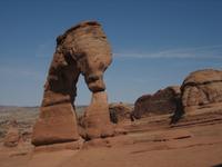
After grabbing breakfast from a supermarket I head to Arches National Park. This parks admission of $10.00 per vehicle is again included in the National Parks Pass. In order to avoid the mid-day heat, the 30 minute hike to beautiful Delicate Arch is the first thing I do. Then, after driving to several viewpoints, I go see the North and South Window, Turret Arch and the Double Arch on foot.
The tiny Dead Horse Point State Park, basically just a 1-mile road on a Mesa, charges an admission of $7.00 per vehicle per day. While not cheap, the view of the Colorado meanders is quite spectacular. I returned again for the view at sunset.
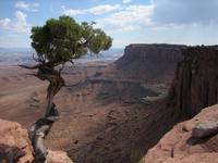 My mere two-week stay in the Southwest allows me only a brief foray into the vast Canyonlands National Park. The per vehicle admission of $10.00 is not charged for owners of the National Parks Pass. I visit the northern part of this essentially three-part park, which is called Island in the Sky. After driving to the tip of the Mesa I hike along the rim, affording great views of the valley. Also a must in this park is the short hike to the Mesa Arch.
|
|
Day 14: Saturday, July 23rd 2005
|
271 miles/436km traveled
|
Moab, UT (09:30)
--->
Wilson Arch, UT
--->
Dove Creek, CO (10:45)
--->
Mesa Verde National Park, CO (11:40-19:00)
Long House Ranger Led Tour (14:00-15:30)
Cliff Palace Ranger Led Tour (17:00-18:00)
--->
Farmington, NM (20:45)
|
|
|
 Weather: Sunny and hot at around 35C (95F), slightly cooler and more clouds in Colorado with heavy evening t-storms (around LaPlata, CO ~19:45)
Cell phone alarm goes off at 07:00, check out is at 08:30.
After another nice pancake breakfast in Moab my stay in Utah draws to a close and I head into Colorado for the day.
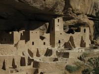
I visit Mesa Verde National Park in the southwestern corner of Colorado. This parks admission of $10.00 per vehicle is again included in the National Parks Pass. Along with some very beautiful forest scenery a great number of ruins of native American cities have been found and are being studied here. Two of these I visit on ranger led tours at $2.75 each: the so called Long House and the Cliff Palace.
|
|
Day 15: Sunday, July 24th 2005
|
331 miles/533km traveled
|
Farmington, NM (08:00)
--->
Bisti Badlands Wilderness Area, NM (09:20-11:40)
--->
Bloomfield, NM (12:50-13:10)
--->
Chaco Culture National Monument, NM (14:15-16:50)
--->
Bernalillo, NM (19:00)
--->
Albuquerque, NM (20:00)
|
|
|
 Weather: Sunny and hot at around 32C (90F), with dark clouds drawing in towards the late afternoon.
Cell phone alarm goes off at 06:45, check out is at 08:00.
After grabbing stuff for breakfast at a gas station in Farmington, NM I head south on US371 to try to make it to the Bisti Badlands Wilderness Area before the midday heat. Unfortunately an oncoming officer catches me being in a hurry (09:00), but after some friendly questions and conversation lets me continue without a ticket.
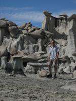
For around 2 hours I hike along a wash in the Bisti Badlands Wilderness Area, which actually contains water after yesterdays rains, marveling at some truly bizarre landscapes and sand and rock formations, including petrified wood.
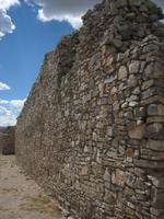
 Chaco Culture National Monument is another park dedicated to the preservation and study of ancient native American cities.
The admission fee of $8.00 is again covered by the National Parks Pass. Chaco is thought to be the origin of the Anasazi indians, who had developed a very advanced civilization and extensive infrastructure including roads leading as far north as Bloomfield.
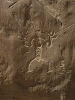
I drive around the parks loop road and spend some time walking through and around the ruins of Hungo Pavi,
Chetro Ketl, Pueblo Bonito, Pueblo Del Arroyo and Casa Rinconada Community (see the Google Maps).
Dark clouds and the late hour stop me from getting a backcountry permit to hike further north and west in the park, which is said to allow a better overview of the impressive size of the ruins.
Chaco Culture National Monument is another park dedicated to the preservation and study of ancient native American cities.
The admission fee of $8.00 is again covered by the National Parks Pass. Chaco is thought to be the origin of the Anasazi indians, who had developed a very advanced civilization and extensive infrastructure including roads leading as far north as Bloomfield.
I drive around the parks loop road and spend some time walking through and around the ruins of Hungo Pavi,
Chetro Ketl, Pueblo Bonito, Pueblo Del Arroyo and Casa Rinconada Community (see the Google Maps).
Dark clouds and the late hour stop me from getting a backcountry permit to hike further north and west in the park, which is said to allow a better overview of the impressive size of the ruins.
I bought a CD of native american music at Chacos visitor center.
|
|
Day 16: Monday, July 25th 2005
|
411 miles/661km traveled
|
Albuquerque, NM (09:30)
--->
Santa Fe, NM (11:00-12:30)
--->
Mountainair, NM (14:00)
--->
Gran Quivira, Salinas Pueblo Missions NM, NM (14:30-16:00)
--->
Roswell, NM (18:30)
--->
Carlsbad, NM (20:00)
|
|
|
 Weather: Sunny and hot at around 32C (90F) in Santa Fe to 38C (100F) around Roswell.
Cell phone alarm goes off at 07:30, check out is at 09:30.
After a bagle breakfast at a Dunkin Donuts I head north for a quick visit to Santa Fe, where I walk around the downtown area near the Governors Mansion and purchase a small indian vase.
Heading back south I stop at the central visitor center for the Salinas Pueblo Missions National Monument in Mountainair, NM. From there I continue south to the Gran Quivira site of the park, which is the largest excavated Native American pueblo and Spanish church. The ruins are impressive and the park gives an interesting insight into the time of the Spanish occupation and relations with the Native Americans at the time.
I bought a book on Indians of the Southwest at the visitor center located directly at the Gran Quivira site.
Driving further south I pass through the small town of Lincoln, famed for Billy the Kid and the five-day Lincoln County War of 1878. The Lincoln State Historic Monument preserves the buildings that figured in the feud. Admittedly, I only read up on this an hour too late, so I didn't do much more than drive through the town...
Driving through Roswell, NM, famed for events in 1947 possibly involving UFOs and extra-terrestrials, I head further south to Carlsbad, where I want to visit a large cave system tomorrow.
I finally start to enjoy the white wine bought with my sister at the Grand Canyon, after buying a corkscrew at Walgreens in Carlsbad.
|
|
Day 17: Tuesday, July 26th 2005
|
390 miles/628km traveled
|
Carlsbad, NM (08:30 Mountain Time)
--->
Carlsbad Caverns National Park, NM (09:00-12:00)
--->
Roswell, NM (14:00-15:00)
--->
White Sands National Monument, NM (17:15-19:15)
--->
Deming, NM (20:45)
|
|
|
 Weather: Awoke to overcast skies for the first time on the trip, which remained most of the day with some clearer skies around noon. The afternoon brought t-storms, with temperatures remaining around 36C (97F) during the day.
Cell phone alarm goes off at 06:55, check out is at 08:15 after needing to call a locksmith to open my car for me for $37.50, the key to which I had accidentally dropped in the trunk...
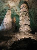
After breakfast bought at a gas station I head to the Carlsbad Caverns National Park. The admission price of $9.00 (for the Natural Entrance/Big Room self-guided tour with a useful audio commentary gadget) is again covered by the National Parks Pass. I spend almost three hours walking through the Natural Entrance and the Big Room, marveling at this truly quite impressive natural wonder (in the middle of the desert!) with many curious and beautiful rock formations.
On this drive through Roswell, NM I stop and tour the UFO Museum and Research Center. It's a very nicely done little place, featuring a collection of newspaper clippings, police reports etc of the infamous 1947 UFO crash here as well as a relatively unbiased presentation of UFO phenomena throughout the world.
After a brief improvement of the weather around noon, I get somewhat unlucky as I reach White Sands National Monument. On the trip there intermittent strong rains are in the area and during my drive through the unique white sand dunes I get mostly clouds with few sunny breaks. Nevertheless the visit does show the completely different nature of this area in comparison to the red rocks and yellow deserts seen previously on the trip.
After the park I head as far west as I can get towards Tucson and check into a Motel 6 in Deming, NM.
|
|
Day 18: Wednesday, July 27th 2005
|
262 miles/422km traveled
|
|
Deming, NM (08:15 Mountain Time)
--->
Tombstone, AZ (10:30-11:00 Pacific Time)
--->
Tucson International Airport, AZ (12:00 Pacific Time)
--->
Denver,Frankfurt,Hannover,Braunschweig (+1,16:00 CET)
|
|
|
 Weather: Awoke to overcast skies again, which cleared once I reached Arizona. Temperatures were around 38C (100F) in Tucson.
Cell phone alarm goes off at 06:55, check out is at 08:15 after filling my trusty ice box for the last time.
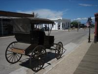
After breakfast bought at a gas station I head west, hoping to make at least one more sight before I have to fly off. After crossing back into Arizona, it turns out seeing Chiricahua National Park is not possible, but at least a brief visit to Tombstone, AZ is, which is the site of the famous gun battle at the OK Corral.
I make it to the airport right at the planned time and return my trusty Pontiac before, wishing I'd have had a few more days, depart the Southwest via Denver and head across the big pond.
|
Things (I know) I missed:
There were a number of choices I had to make as there is only so much you can do in two weeks. Since there is so much to see in the Southwest, some great things will have to wait for another trip; the ones I know about are listed below.
- Chircahua National Monument, AZ:
[Google Map]
- Petrified Forest National Park, AZ:
[Google Map]
- Canyon de Chelley National Monument, AZ:
[Google Map]
- The midday "beams" at the Lower or Upper Antelope Canyon, AZ:
[Google Map]
- Wahweap Hoodoos near Big Water in UT:
[Google Map]
These rock formations were recommended to me by the rangers at the BLM Paria Station and I have since learned they are right up there with The Wave in terms of beauty and uniqueness.
- Grand Staircase Escalante National Monument:
[Google Map]
This Clinton-designated National Monument is huge, and I've heard of many fascinating things to see, such as the Rainbow Bridge (actually a separate National Monument on the southern perimeter of the Escalante area, which is accessible only on foot and/or boat) and the Lower Calf Creek Falls.
- Coral Pink Sand Dunes, UT:
[Google Map]
I drove past this state park a bunch of times in the Kanab area, but always too late in the afternoon to stop by.
- Capitol Reef National Park, UT:
[Google Map]
The short length of my stay and the focus on The Wave (no regrets there though!) meant I couldn't drive the more usual route north of Bryce Canyon through this park to get to Arches.
- Canyonlands, UT:
[Google Map]
I only got a small taste of this park in the form of the Island in the Sky district. This park is gigantic and made up of three separate parts (Island in the Sky, The Maze and Needles). Each of them do require (and I am sure are worth) spending around a day exploring, and are possibly best experienced in the combination hiking/off-road driving.
- White Sands Missile Range Museum, NM, about 50 miles west of Alamogordo on US70
- The New Mexico Museum of Space History in Alamogordo, NM:
[Google Map]
- The nightfall flight of the bats at Carlsbad Caverns, NM:
[Google Map]
- The visitor center exhibits, museums and films at all of the parks do seem to be very well done and informative and are probably worth more than the brief walk-through I did.
- I could very well have spent more time at pretty much all of the sights I visited
|
|
|
|

)
'))
)
)
)
)
)
)
)
)
)
)
)
)
)
)
)
)
)
)
)
)
)
)
)
)
)
)
)
)
)
)
)
)
)
)
)
)
)
)
)
)
)
)
)
)
)
)
)
)
)
)
)
)
)
)
)
)
)
)
)
)
)
)
)
)
)
)
)
)
)
)
)
)
)
)
)
)
)
)
)
)
)
)
)
)
)
)
)
)
)
)
)
)
)
)
)
)
)
)
)
)
)
)
)
)
)
)
)
)
)
)
)
)
)
)
)
)
)
)
)
)
)
)
)
)
)
)
)
)
)
)
)
)
)
)
)
)
)
)
)
)
)
)
)
)
)
)
)
)
)
)
)
)
)
)
)
)
)