|
|
|

|
Southwest USA 2005
July 10th - July 27th 2005
|
|
|
|
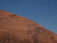
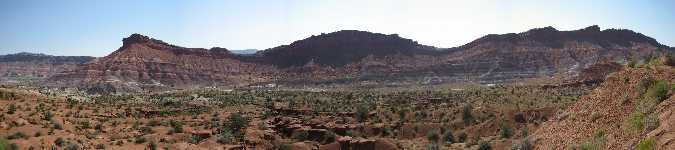
The Arizona-Utah border, in particular the region along highway US89 between Kanab, UT and Page, AZ offers access to an extremely rich variety of natural marvels.
These include the Grand Staircase Escalante National Monument, the Glen Canyon National Recreation Area as well as the Paria Canyon Wilderness and Vermillion Cliffs National Monument.
Additionally, some man-made structures are worth visiting here, such as the Navajo Bridge across the Colorado River, which can be reached via US89A, as well as the Glen Canyon Dam just west of Page, AZ.
|
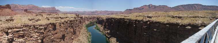
Marble Canyon and the Navajo Bridge over the Colorado River
|
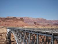
Navajo Bridge at Marble Canyon
|
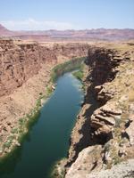
The Colorado as seen from Navajo Bridge at Marble Canyon
|
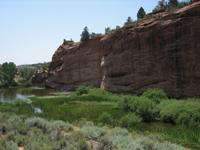
Lush green oasis along US89 just outside of Kanab, UT
|
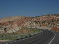
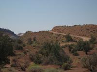
US89 between Page, AZ and Kanab, UT
|
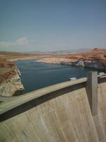
Construction of Glen Canyon Dam began in 1956...
|
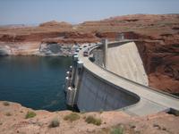
...and led to the creation of the countries second largest artificial reservoir, Lake Powell
|
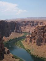
The Colorado River downstream of the Glen Canyon Dam
|
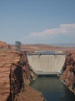
Glen Canyon Dam stands 710 feet tall
|
|
|
|
|
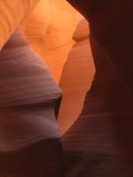
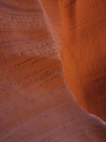
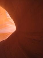
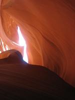
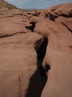
The most breathtaking definition of a slot canyon can be experienced in the Lower and Upper Antelope Canyons, located on a Navajo Reservation a few miles east of Page, AZ on US98 (near the Navajo Power Plant).
Also known as Corkscrew Canyon, alluding to the narrow winding passages formed through erosion by wind and water, these beauties are best experienced in the midday hours, when the diffuse sunlight filters through the canyons narrow upper openings casting the beautifully structured canyon walls in glowing pastel orange tones.
A highlight I missed (partly because this is a well-known highlight drawing large crowds) are the "beams" around noon, when the rays of the suns actually directly reach the canyon floor.
Tours of the canyons are Navajo-led, with the Upper Antelope Canyon entrance a jeep-drive away from the marked parking lot, while the Lower Antelope canyon is only a few steps from the ticket office for this part of the canyon.
The canyons are owned and operated by two Navajo families, and admission fees are $21 for the Upper and $18.50 for the Lower Antelope Canyon are charged.
|
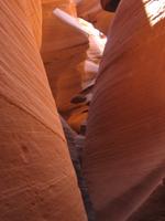
Narrow corkscrew passages...
|
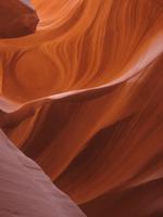
...and swirling structures in the walls...
|
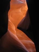
...are hallmarks of a slot canyon.
|
Lower Antelope Canyon
|
Beautifully smooth walls
|
Diffuse lighting from above
|
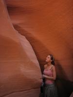
Marveling at the Lower Antelope Canyon
|
Looking up in the slot canyon
|
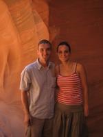
Happy and impressed visitors
|
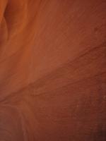
Close up of the canyon walls
|
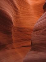
Sweeping canyon walls
|
The remarkably unspectacular entrance area to the Lower Antelope Canyon
|
|
|
|
|
|
Las Vegas, Nevadas largest city located in the south-eastern corner of the state, requires no introduction.
Famed for the glitzy casino hotels and the nightlife, the city continues to grow and at the very least offers an entertaining contrast to the natural wonders I focused on during this trip.
|
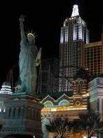
New York, New York in Las Vegas, NV
|
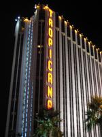
The Tropicana on the Las Vegas Strip
|
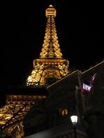
Paris Eiffel Tower in Las Vegas, NV
|
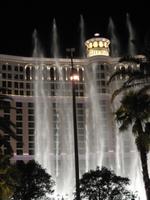
The Bellagio water fountain show
|
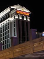
The gigantic Caesars Palace Hotel and Casino
|
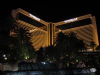
The Mirage Hotel and Casino...
|
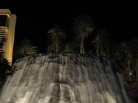
...with a half hourly...
|
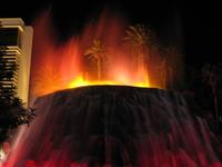
...eruption of a volcano
|
|
|
|
|
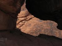
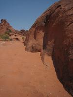
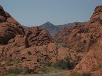
Driving a few miles east along US169 from Exit 75 of I15 north of Las Vegas, NV gets you to Valley of Fire State Park.
This is Nevadas oldest and largest state park and is aptly named for the red sandstone formations and the stark beauty of the Mojave Desert.
Along with the beautifully deep red eroded entrada sandstone rocks, the park preserves evidence of ancient forests in the shape of petrified logs as well as the mark of early inhabitants of the area in the form of 3,000 year-old Indian petroglyphs.
While it offers a spectacular experience to the short-term visitor like myself along the paved roads winding through the park, many people say spending more time to wander into the back country of the park is well worth setting aside a day or two for.
As a state park the National Parks Pass is no good here, and an admission fee of $6 per vehicle is currently charged.
|
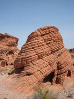
Eroded sandstone "Beehives"
|
Fire red rocks
|
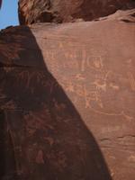
Ancient Indian petroglyphs can be found on Atlatl Rock
|
Deep red rocks and rich blue skies
|
A log of petrified wood, remnant of an ancient forest
|
Fine red dust at Mouses Tank
|
The road through the Valley of Fire
|

Funky orange Pontiac Sunfire blending in
|
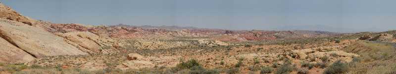
A view across the colorful Valley of Fire
|
|
|
|
|
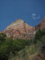
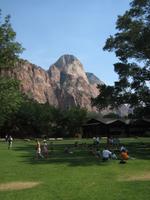
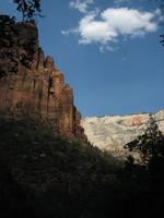
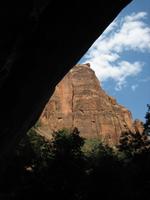
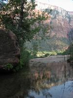
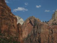
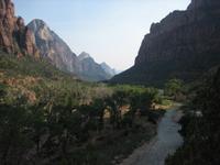
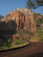
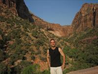
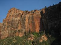
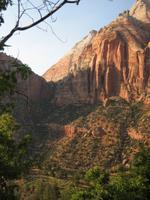
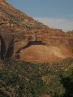
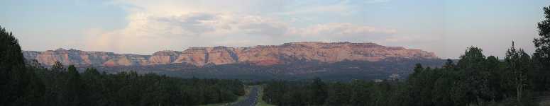
Zion National Park, located on the Colorado Plateau in south-western Utah, is reached via US9, which essentially connects the cities of St George and Kanab (well, close enough for the purposes of locating it on a map).
The park features high plateaus, a maze of narrow, deep, sandstone canyons and striking rock towers and mesas.
The North Fork of the Virgin River has carved a spectacular gorge, Zion Canyon, with canyon walls in most places rising 2000-3000 feet above the canyon floor.
Access to this part of the park is with a shuttle bus.
The impression of the park I got on my half-day visit, aside from the again truly marvellous rock formations, is that of a perfect place for a family vacation.
Hiking trails for all skill levels as well as swimming in designated areas of the Virgin River are some of ways to spend time here, with more information available at the visitors center.
An admission fee of $20 per vehicle is charged for a week but is included in the National Parks Pass.
|
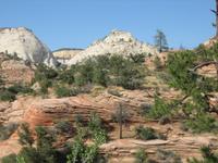
White meets red at Zion
|
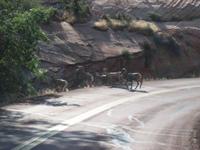
The Big Horn Sheep cross the road
|
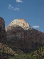
Play of the sunlight on Zions peaks
|
Red peaks rise behind lush green trees
|
A great place for a picnic or a rest before hiking to the Emerald Pools
|
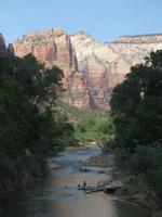
Cooling down in the Virgin River
|
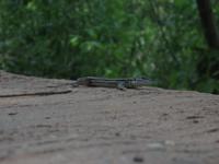
Eye-to-lens with a lizard
|
Red meets white meets green
|
A view of Zion from the shade of a ledge near the lower Emerald Pools
|
Reflections in the Middle Emerald Pools
|
The red walls of the Virgin Canyon
|
Descending Kayenta trail back towards the Virgin River at the Grotto
|
The evening sun makes for even richer reds
|
Thats the real thing behind me, even if it does look like a photo-studio set
|
Spectacular colors in the evening sunlight
|
Spectacular colors in the evening sunlight
|
Spectacular colors in the evening sunlight
|
Spectacular colors in the evening sunlight
|
Spectacular colors in the evening sunlight
|
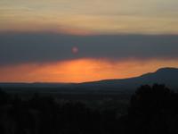
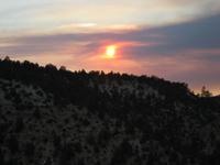
Wildfire smoke plays with the setting sun
|
The sun sets over US9 snaking out of Zion National Park towards the east
|
|
|
|
|
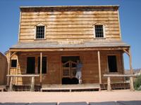
The Old Paria Movie Set is located on the southern fringes of the Grand Escalante National Monument, about half way along US89 between Page, AZ and Kanab, UT.
Purpose built as a movie set, this small western town was featured in several Hollywood Westerns between 1963 and 1976, including Clint Eastwoods "The Outlaw Josey Wales".
While the original wooden buildings were destroyed in a series of flash floods in 1999, they were rebuilt and are well worth a short excursion, since the location in the midst of the wonderfully colorful chinle sandstone Painted Desert is quite breathtaking.
|
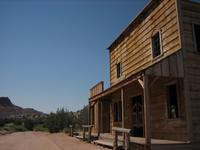
Sole street past the "Lost Lady", post office and "Red Rock saloon"
|
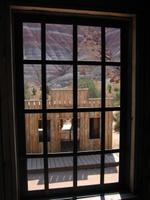
View of "Red Rock Saloon" from the "Lost Lady"
|
Howdy from the Lost Lady! I'm not much of a cowboy I guess...
|
Dust road out to the Old Paria Movie Set
|
Fantastic views of the Painted Desert driving out to the Old Paria Movie Set
|
|
|
|
|
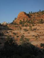
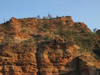
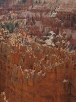
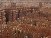
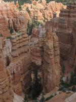
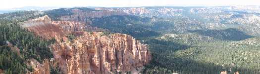
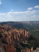
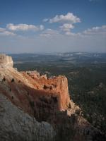
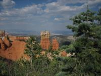
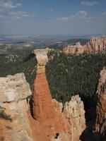
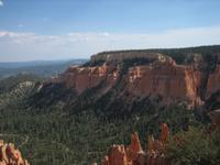
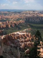
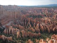
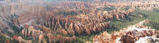
Located in south-western Utah, Bryce Canyon displays what is probably the culmination of the spectacular eroded rock formations known as hoodoos.
Arranged in several horseshoe-shaped amphitheaters along the eastern edge of the Paunsaugunt Plateau, erosion has shaped a vast maze of colorful Claron limestone, sandstone, and mudstone spires, fins and pinnacles.
The park can be explored on a paved road in your own vehicle or using a shuttle bus service.
Several viewpoints allow spectacular vistas of the marvelous rock formations.
Information on hiking trails is best obtained at the parks visitors center.
The admission fee is $20 per vehicle, or included in the National Parks Pass.
|
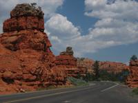
Red Canyon near Bryce Canyon
|
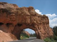
Probably not a natural bridge at Red Canyon near Bryce Canyon
|
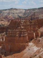
Hoodoos in the Bryce Amphitheater
|
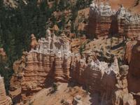
White tipped hoodoos in the Bryce Amphitheater
|
Hoodoos in the Bryce Amphitheater
|
Strangely grouped hoodoos in Bryce Amphitheater
|
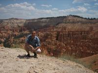
Speechless in the Bryce Amphitheater
|
Bryce Amphitheater
|
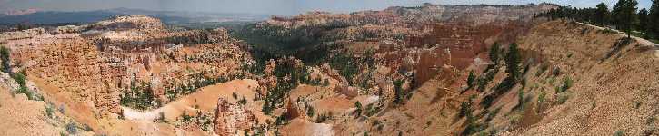
Bryce Amphitheater viewed from Sunset Point
|

Breathtaking mass of hoodoos in the Bryce Amphitheater
|

View from Bryce Canyons Rainbow Point
|
The view from Bryce Canyons Rainbow Point
|
View from Bryce Canyons Rainbow Point
|
View from Bryce Canyons Yovimpa Point
|
View from Bryce Canyons Black Birch Canyon Viewpoint
|
View from Bryce Canyons Black Birch Canyon Viewpoint
|
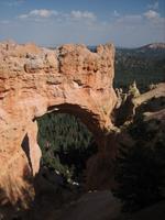
View of Bryce Canyons Natural Bridge
|
Paria View at Bryce Canyon
|
View over Bryce Amphitheater from Bryce Point
|
View over Bryce Amphitheater from Bryce Point
|
Another spectacular view over the Bryce Amphitheater from Bryce Point
|
Another breathtaking sunset as I head back to Kanab, UT
|
|
|
|
|
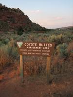
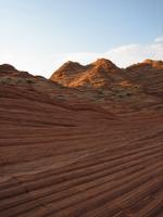
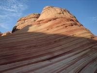
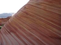
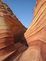
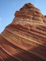
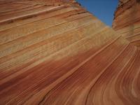
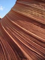
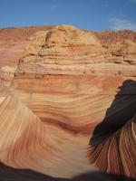
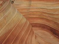
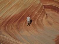
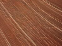
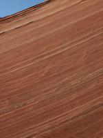
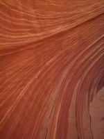
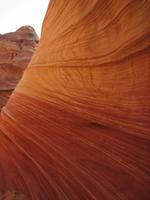
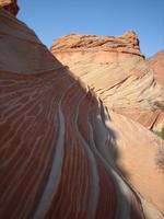
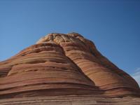
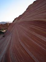
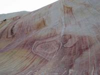
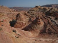
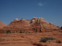
You've most likely seen this natural marvel on posters and postcards but will be hard pressed to find much information on it in your typical travel guides for the Southwest.
For good reason. The Wave, located somewhere between Page, AZ and Kanab, UT on the border between these two states, is as beautiful as the images - but it's also very fragile.
Mass tourism is not something The Wave would be able to wether very well, so thanks to an excellent effort by the Bureau of Land Management (BLM) anyone has a chance to go and see this sandstone wonder for a negligible fee of $5, a little planning, possibly a bit of patience and a 6 mile hike through the beautiful wilderness of the Vermillion Cliffs National Monument.
The BLM limits the number of visitors to The Wave to 20 people a day. Permits can be obtained through the BLM in two ways:
About 30 miles west of Page, AZ on US89 is the BLMs Paria Contact Station. Every day at 9 AM (Utah Mountain time!) a lottery is conducted for 10 permits to The Wave (Coyote Buttes North Unit) for the following day.
Naturally, if fewer than ten people show up the lottery isn't necessary, as was the case for my mid-summer trip.
If you miss out in the lottery on your first try, returning again on the following day is rewarded with a doubling of your chances in that days lottery.
Along with the permits, a set of excellent detailed information on the hike through the Vermillion Cliffs wilderness (no marked trails here!) is handed out.
During the winter months (November through early March), the BLMs Kanab office is responsible for the walk-in permit lottery, as the Paria Contact Station is closed.
The other 10 daily permits are obtainable through the BLMs website.
As of January 2006 these 10 permits become available at 12 noon Mountain Time on the first of each month for the following 4 months.
A credit card, good timing and a bit of luck are all that's required since the permits sell out within hours or days depending on the season.
The trailhead to The Wave is reached by driving about 8 miles on a dirt road heading off of US89 a few miles west from the Paria Contact Station.
I'm being deliberately vague here, as this information is best obtained at the BLM office. Anyway, a $300 fine is charged if you get caught without a permit, with rangers not infrequently patrolling the area.
From the trailhead it's an easy/moderately strenuous 3-mile hike to get to The Wave.
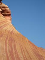
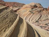
Next to the breathtaking swirling sandstone beauty of The Wave itself, there's other attractions close by (The Second Wave, The Teepees to name of few), some of which I will have to go back to see myself...
|
Start of the 3 mile hike to The Wave - and please, respect the sign!
|
A taste of things to come on the way to The Wave
|
The entrance to The Wave
|
Looking out the entrance of The Wave
|
Sandy floor of a side canyon of The Wave
|
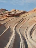
A towering part of The Wave
|
The undulating Wave
|
Delicate ridges on The Wave
|
Overlooking the heart of The Wave
|
The Wave sweeping west
|
Awestruck in the middle of The Wave
|
A wall of The Wave up close
|
The crest of The Wave
|
The bottom of The Wave
|
Looking out The Waves west entrance
|
The Waves western face
|
The Wave, Vermillion Cliffs, UT/AZ
|
The Waves northern face
|
The Wave rising towards the entrance
|
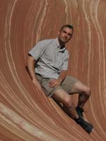
Riding The Wave
|
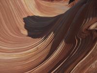
The swirling Wave
|
The Wave, Vermillion Cliffs, UT/AZ
|
The Second Wave
|
The Second Wave
|
Much more beauty to see nearby too...
|
The Wave, compact wonder
|

One last look out of The Wave before hiking back
|
Beautiful and unique rocks on the hike back
|
|
Movies
|

The Waves northern entrance
|
|
|
|
|
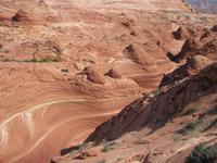
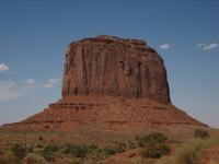
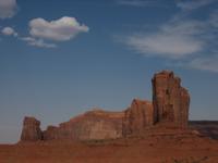
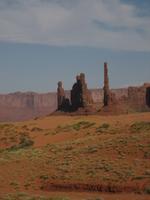
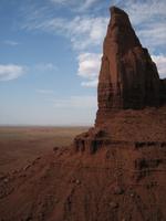
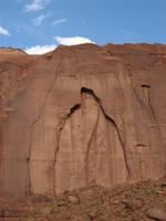
Another natural spectacle in the US Southwest requiring no introduction is Monument Valley Tribal Park, seen in numerous TV commercials and Hollywood Westerns.
Located in western Arizona just south of the Arizona-Utah border it is reached via a road heading off of US163.
A 17 mile dirt road (a little bumpy but driveable in a regular car) takes you past the spectacular sheer red buttes and mesas rising into the blue Arizona sky.
The Navajo also offer guided tours, with information best obtained at the Parks visitors center, which also sells Navajo arts and crafts.
Park admission is $5 per person, naturally not part of the National Parks Pass.
|
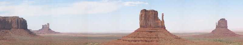
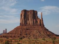
Panoramic view of Monument Valley Tribal Park featuring the East and West Mitten Buttes
|
The Monolith
|
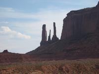
The Three Sisters
|
The Elephant Butte
|
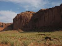
The Hub plus a horse - a picture that just had to be taken, even without a smoking cowboy.. :-)
|
The Totem Pole and Yei Bi Chei
|
Artists Point
|
Monument Valley, AZ
|
Mitten Butte in the late afternoon
|
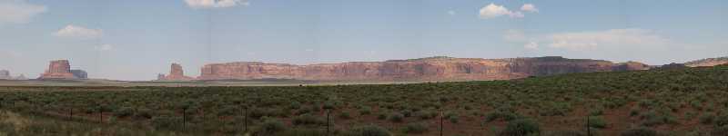
Panoramic view of Monument Valley Tribal Park in the late afternoon sun
|
|
|
|
|
|

)
)
)
)
)
)
)
)
)
)
)
)
)
)
)
)
)
)
)
)
)
)
)
)
)
)
)
)
)
)
)
)
)
)
)
)
)
)
)
)
)
)
)
)
)
)
)
)
)
)
)
)
)
)
)
)
)
)
)
)
)
)
)
)
)
)
)
)
)
)
)
)
)
)
)
)
)
)
)
)
)
)
)
)
)
)
)
)
)
)
)
)
)
)
)
)
)
)
)
)
)
)
)
)
)
)
)
)
)
)
)
)
)
)
)
)
)
)
)
)
)
)
)
)