|
|
|

|
Southwest USA 2005
July 10th - July 27th 2005
|
|
|
|
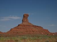
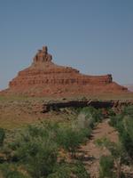
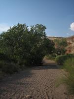
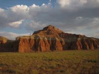
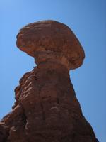
In many other states this valley of impressive red sandstone buttes would be a designated state or national park, but in natural wonder spoiled Utah Valley of The Gods has to hold its own as a BLM administered area.
And it does, with the comparison to its larger neighbor Monument Valley justified.
Located a few miles north of Mexican Hat in southern Utah, the varied and wonderful rock formations, which Navajo legend describes as ancient warriors frozen in time, can be explored on a drive on a 17-mile dirt road,
which connects highways US163 and US261.
|
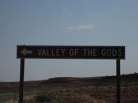
Valley of the Gods, UT
|
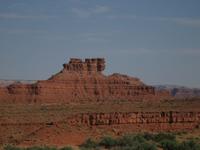
Monument Valleys smaller but equally fascinating sibling
|
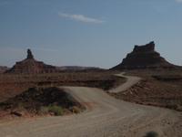
A 17-mile dirt road curves through the valley...
|
...past red rocks...
|
...brilliant red and varied spires...
|
...and spectacular sandstone sculptures...
|
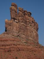
...which Navajo legend describes as ancient warriors frozen in time.
|
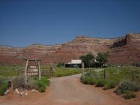
The solar- and wind-powered Valley of the Gods Bed and Breakfast, right in the Valley
|
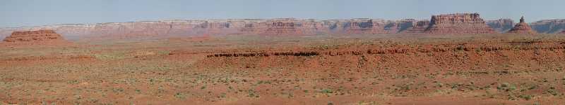
Panoramic view of the Valley of the Gods, with the 1,200-foot Cedar Mesa bluff in the background
|
|
|
|
|
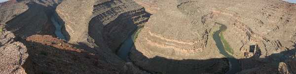
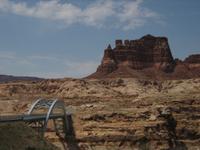
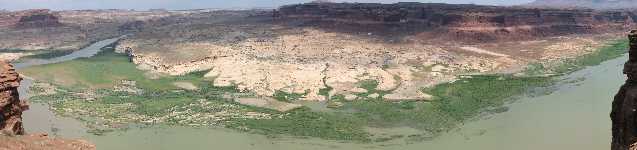
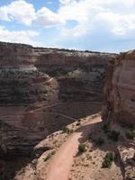
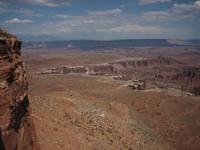
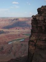
Goosenecks State Park is located a few miles north of Mexican Hat in southern Utah and at the southern end of highway US261.
While it's little more than an overlook, the view here is quite spectacular, showing the impressive meandering curves the San Juan River has carved into the desert landscape 1100ft below.
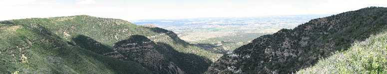
Continuing north on US261 takes you up onto Cedar Mesa via a wonderfully serpentine (albeit partly gravel) road.
At the top of the mesa, dirt road 241 will takes you to Muley Point Overlook, a little know vantage point with more breathtaking views of the San Juan River serpentines.
|
The Meandering San Juan River viewed from Goosenecks State Park, UT
|
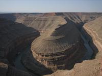
The Meandering San Juan River viewed from Goosenecks State Park, UT
|
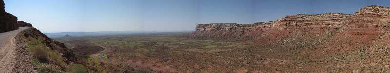
Serpentine turns of highway 261 up onto Cedar Mesa towards Muley Point
|
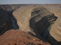
The Meandering San Juan River viewed from Goosenecks State Park, UT
|
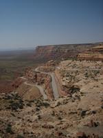
Serpentine turns of Highway 261 towards Muley Point
|
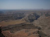
The San Juan River has carved spectacular serpentines into the landscape
|
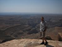
Walking on the edge at Muley Point
|
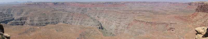
Panoramic view over the San Juan goosenecks from Muley Point, with Monument Valley in the background haze
|
|
|
|
|
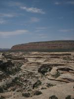
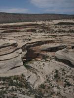
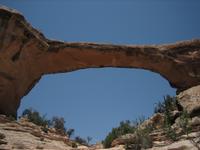
Natural Bridges National Monument is Utahs oldest National Parks Service designated site and is located in the southeastern corner of the state, just off of US95 near the intersection with US276.
It is home to three so-called Natural Bridges, with the Hopi names Sipapu, Kachina and Owachomo, which were formed when meandering streams eroded the canyon walls of the mesa.
Furthermore, a very well preserved ancestral Puebloan site, the Horsecollar ruin, can be viewed here - unfortunately only from relatively far away, which is located below a ledge at the foot of a canyon.
|
Natural Bridges National Monument, Utahs first national park
|
Sipapu Bridge
|
Sipapu Bridge
|
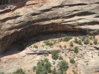
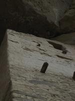
The Horse Collar Ruin in the shade of an overhang
|
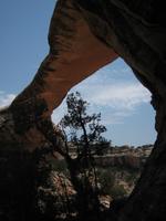
Owachomo Bridge
|
The thin span of Owachomo Bridge...
|
...shows its the oldest of the three bridges in the park
|
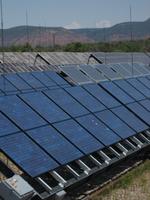
Natural Bridges National Monument (visitor center) is entirely solar powered
|
|
|
|
|
What I feared would be a boring drive to get from southern Utah to the central part ended up being a truly memorable experience and one of the greatest stretches of road I've driven.
US95 is designated a "scenic byway", and they're not kidding.
Connecting Blanding in the Southeast with Hanksville, it winds through an ever-changing landscape of sheer red rock canyons, white cliffs and desert landscapes ranging from arid to alive with green shrub vegetation.
And what's more, it seems to be a road less travelled, so you can enjoy the scenery on your on terms.
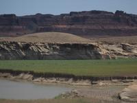
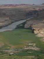
A highlight is definitely the roads passage through the Glen Canyon National Recreation Area near Hite, formerly a mining boom town, now merely home to a marina and an airfield.
After crossing a bridge over the Colorado River, US95 meanders over and around one of the streams tributaries before climbing up into the red rocks.
There, a sign points out a scenic spot not to be missed: the Hite Overlook.
It offers an awesome view across a particularly wide part of the Colorado River valley, with fantastically lush green vegetation lining the river shore, contrasting sharply but beautifully with the sheer red canyon walls all around.
Another nice spot is a few miles north on US95 West, a picnic area called Hog Springs.
On my next trip I will try to drive the much talked about highway US12 on the other side of the Capitol Reef National Park.
Hard to imagine that there's more roads like US95 in Utah.
|
A truly beautiful drive along US95, over the Colorado River near Hite...
|
...with a great view over the Colorado River...
|
...which is topped only by the view from Hite Overlook
|
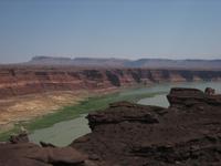
View of the Colorado River from Hite Overlook
|
View of the Colorado River from Hite Overlook
|
Scenic Byway US95 West tuned out to be one of my nicest drives of the trip
|
|
|
|
|
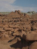
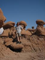
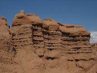
Goblin Valley State Park is located is located about 20 miles north of Hanksville in southern Utah and is reached driving about 12 miles west from Highway US24. Spread across three linked valleys, this park showcases another unique result of the forces of erosion.
Deposits of entrada sandstone have been remodeled through the combination of water erosion and smoothing by wind blown dust into mushroom like formations, which resemble little goblins.
This unique, outer-worldy landscape was featured as a backdrop for the movie "Galaxy Quest".
The park invites visitors to explore the valleys, with fun hikes amongst the goblins and through dried water channels worth spending a few hours.
As a State Park, the National Parks Pass doesn't get you in here, so an admission fee of $5 per vehicle is charged.
|
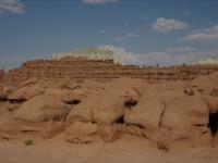
Yet more spectacular variation of red rock...
|
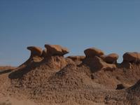
...somewhere between mushroom like formations...
|
...and little gnome-like statues...
|
...fill three valleys at Goblin Valley State Park
|
Highland deposits of Entrada Sandstone in this valley...
|
...formed the basis out of which...
|
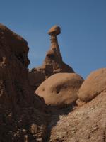
...over time the forces of wind and water...
|
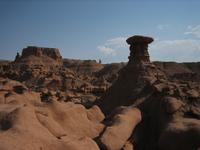
...sculpted a wide array of goblins or mushroom rock formations.
|
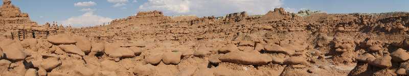
Three entire valleys are populated with innumerable of these goblins
|
|
|
|
|
|
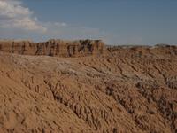
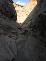
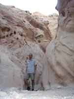
About 6 miles west into the San Rafael Swell from Goblin Valley State Park another marvel in the Utah rocks landscape awaits.
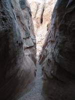
The Little Wild Horse Canyon can be categorized as a slot canyon, but it offers a very different interpretation of this theme than does the Antelope canyon.
Hiking through the canyon is a blast, thanks to the canyons constantly changing width, ranging from large rooms to passages barely wider than shoulder width with the canyon walls almost touching at ground level, along with an occasional small rock obstruction to circumvent.
I was there late, around 6pm, but all alone (all day from what I could see at the log book), so I only walked about 3/4 of the length of the Little Wild Horse Canyon.
The recommended route, also marked on a topo-map available in boxes at the parking lot, is to walk the 9 mile loop beginning with the Bell Canyon and taking the fun Little Wild Horse back.
|
A wash leads out to the canyon
|
Occasionally smaller climbs are necessary in the canyon
|
The canyon goes from wide areas...
|
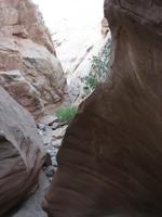
...to narrow passages...
|
...to tight spaces, little wider than shoulder width.
|
Evening sun coloring the rocks on my return from Little Wild Horse Canyon
|
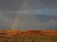
Rainbows and clouds on my return from Little Wild Horse Canyon
|
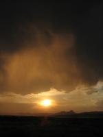
Sunset in the rain clouds on my return from Little Wild Horse Canyon
|
|
|
|
|
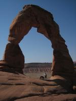
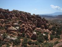
Arches National Park, located just off highway US191 north of Moab in Utah, is dedicated to the preservation of over 2000 natural sandstone arches, with the most famous being the Delicate Arch. These beautiful entrada and navajo sandstone geologic features were created from the so called "Paradox Formation", a salt bed on which the park lies. During colder periods, water that seeped into the rock was frozen into ice, and the corresponding volumetric expansion put pressure on the rock, breaking off bits and pieces, and sometimes creating openings - the arches.
The park boasts the greatest density of the rock formations worldwide, with some viewable from overlooks along the parks road and many more best seen up-close on varying length and difficulty hikes. A brand new visitor center is about to be opened in late 2005, which along with informative exhibits and the obligatory souvenirs also offers visitors the opportunity to consult park rangers on the various activities possible in the park.
The per vehicle admission fee is currently $10 for a week, but again included in the National Parks Pass.
|
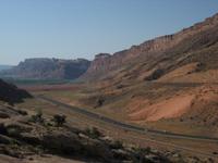
The Moab Fault, Highway 191 and the park entrance road
|
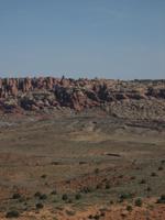
The Salt Valley
|
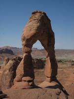
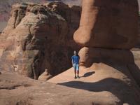
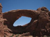
The Delicate Arch
|
People having fun in the Delicate Arch
|
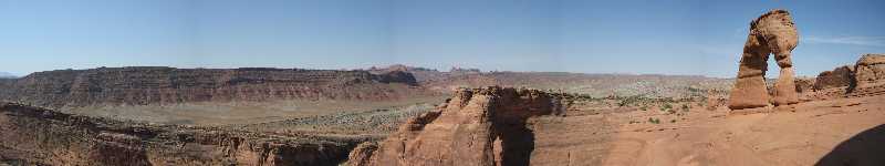
A panoramic view of the Delicate Arch
|
Standing in the Delicate Arch
|
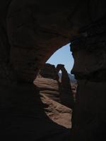
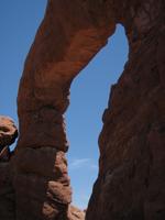
The Delicate Arch viewed through an arch
|
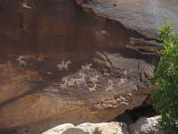
Ute rock art from the 18th century at the Delicate Arch Trailhead
|
The Fiery Furnace
|
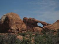
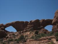
The Turret Arch from afar...
|
...and up close
|
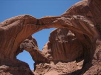
The South Window
|
North and South Window Arches viewed from the less populated back trail
|
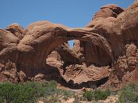
The Double Arch from afar...
|
...and up close.
|
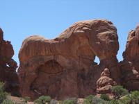
The Parade of Elephants
|
Balanced Rock
|
|
|
|
|
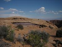
Canyonlands is a vast and rugged National Park and features a very colorful and varied landscape of sedimentary sandstones, which the Colorado River and its tributaries have eroded into canyons, mesas and buttes.
The Colorado and Green rivers divide the park into four separate districts, which are all essentially separate entities with their own access roads and visitor centers: the Island in the Sky, the Needles, the Maze and the rivers themselves.
On my trip I only managed to spend half a day in the Island in the Sky, the most accessible of the districts, which is good for only an impression of the undisturbed Colorado Plateau preserved here.
This part of the park is reached on a road leading west from US191 just north of Moab, UT.
Highlights of this part of the Park are the Mesa Arch, which is precipitously perched right on the edge of a cliff, the Grand View Point Overlook, with views across the Canyonlands to the south including the Monument Basin and its White Rim as well as Upheaveal Dome.
Due to the rugged nature of the park and the vast expanses, probably the best way to experience the spectacular nature here is to spend a few days to hike, mountain bike and/or drive the dirt roads such as the White Rim Road through the back country in a 4WD vehicle.
I know that's something I hope to so on a future trip here.
Park admission is $10 per vehicle for a week, or included in the National Parks Pass.
|
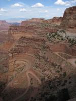
Shafer trail: 4WD high clearance vehicle required, un guaranteed
|
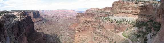
View of the Monument Basin and White Rim from the Grand View Point Overlook
|
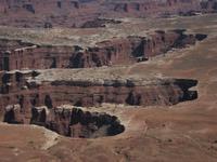
The White Rim zoomed in from Grand View Point Overlook
|
I think this is my favorite picture (hard choice though!), taken along the Grand View Point Overlook
|
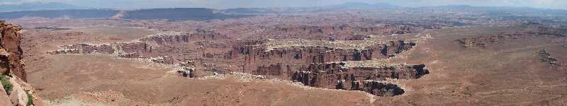
View from the Grand View Point Overlook of Canyonlands "Middle Ground", the Monument Basin and White Rim 1000ft below
|
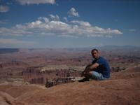
Overwhelmed at the rim of the Island in the Sky
|
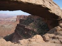
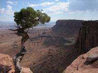
A SE-glimpse through Mesa Arch, set on the edge of the rim
|
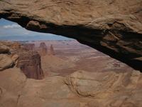
And looking east through Mesa Arch
|
Mesa Arch, perched on the rim
|
Next time I'll get a 4WD...
|
View of the Shafer Canyon and Trail
|
|
|
|
|
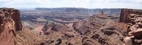
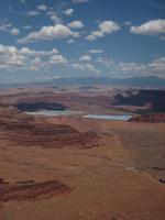
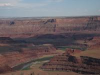
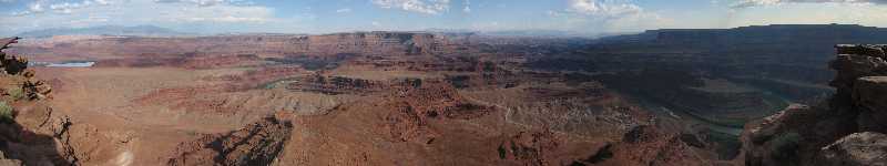
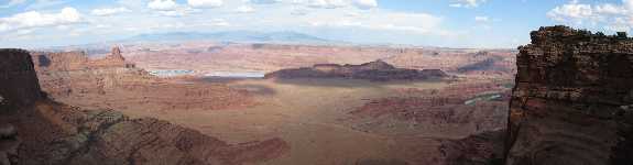
Dead Horse Point State Park is a tiny 1-acre park right on the way from Moab to the Canyonlands Island in the Sky district.
While not a bargain at the $7 admission fee charged per vehicle and day, the view from the rim of the mesa at Dead Horse Point Overlook is stunning:
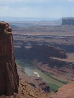
The spectacular red rock scenery of Canyonlands, with the Colorado River, flanked by lush vegetation, meandering its way through deep ravines and the La Sal Mountains in the background.
Both a bit of scar on the landscape while strangely beautiful at the same time are the two turquoise Moab uranium mill tailings, storing the crushed sand from which uranium has been mined, is visible to the southeast.
|
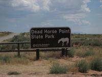
Dead Horse Point State Park, UT
|
View of the serpentine Colorado River from the Meander Overlook
|
View from the Meander Overlook
|
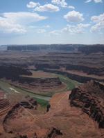
View from the Meander Overlook
|
The Moab uranium mills tailings in the SE-view from Dead Horse Point
|
SE-view from Dead Horse Point
|
Southerly view from Dead Horse Point with the La Sal Mountains way in the back
|
SE-panorama from Dead Horse Point
|
View of a Colorado River serpentine from Dead Horse Point
|
|
|
|
|
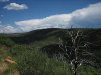
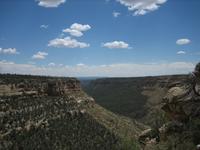
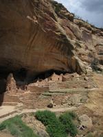
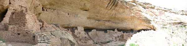
Mesa Verde is Spanish for "green table", and describes one aspect, the beautiful lush greenery of the landscape of this park very well.
The main focus of this park, located in the southwestern corner of Colorado, is the excavation, preservation and study of a great number of ancient Puebloan archaeological sites, including some truly impressive so-called cliff dwellings, skillfully built in the sheltered alcoves of the canyon walls.
The park allows a unique glimpse into the cultural history of the American Southwest and into the lives of the people that inhabited the area from 700 through 1300 AD.
Research of the ruins found here is ongoing, with scientists also consulting with the contemporary indigenous descendants of the Puebloan people - 24 Native American tribes trace their roots to the sites found at Mesa Verde - in an effort to understand more of how they lived and why they so suddenly disappeared.
Taking one or more of the three ranger led tours to the Cliff Palace and Balcony House ruins on Chapin Mesa, and the Long House Ruins on Wetherill Mesa is pretty much a must, with each currently costing $2.75 per person and several tours available each day.
Many other archaeological sites can be seen from scenic spots along the roads running along the mesas and on several hikes of varying length.
Park admission is $10 per vehicle and week, waived when you flash the National Parks Pass at the park entrance.
|
Panoramic view across the green mesa that is Mesa Verde National Park
|
Mesa Verde National Park proves to be aptly named...
|
...on the drive past the entrance to the visitor center...
|
...with great views across green slopes and mesas.
|
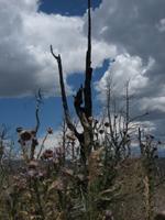
Evidence of a recent wildfire
|
The lush greenery on the edge of Wetherill Mesa
|
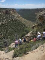
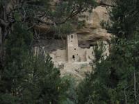
Stairway down the mesa to the Long House ruins
|
The Long House ruin...
|
...was excavated between 1959 and 1961.
|
It's the second largest cliff dwelling in the park...
|
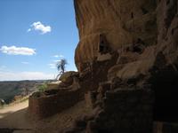
...and was inhabited between 1200 and 1300 AD
|
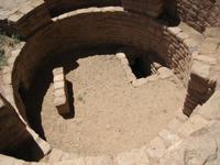
Looking into one of 19 ceremonial kiva at the Long House ruin
|
An estimated 150 Anazasi...
|
...called Long House home over 700 years ago.
|
Panoramic view of the Long House ruin, including remnants of storage rooms on a ledge
|
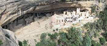
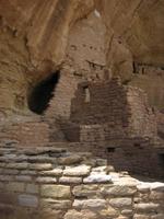
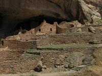
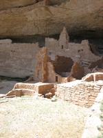
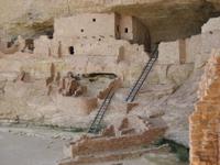
Cliff Palace is the largest of the excavated dwellings at Mesa Verde.
|
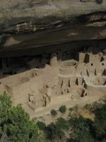
Looking down at the Cliff Palace ruins
|
The Cliff Palace ruins
|
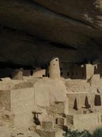
The Cliff Palace ruins
|
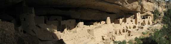
Cliff Palace had up to 200 rooms...
|
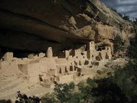
...in structures up to three stories tall...
|
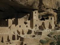
...and exhibited skillful stone masonry.
|
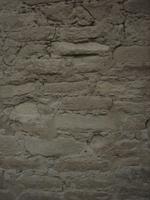
Masonry detail at the Cliff Palace ruins
|
Masonry detail at the Cliff Palace ruins
|
|
|
|
|
|

)
)
)
)
)
)
)
)
)
)
)
)
)
)
)
)
)
)
)
)
)
)
)
)
)
)
)
)
)
)
)
)
)
)
)
)
)
)
)
)
)
)
)
)
)
)
)
)
)
)
)
)
)
)
)
)
)
)
)
)
)
)
)
)
)
)
)
)
)
)
)
)
)
)
)
)
)
)
)
)
)
)
)
)
)
)
)
)
)
)
)
)
)
)
)
)
)
)
)
)
)
)
)
)
)
)
)
)
)